Coffee XXXII Apr. 14th


Status
Not open for further replies.
Cancer can go BEEEEP!!! itself...:mad::mad:
That's right. Let it know you mean business. I hope the treatments continue to help.


Good morning. It's 76°.
30.gif


Heat Index: 76°F Humidity: 94% Dew Point: 75°F

High: 81°F Low: 74°F
Rain: 0.01" Rain Rate: 0.00"/h
Gust: 7mph SSW

High: 92°. Partly cloudy with a 30 percent chance of showers and thunderstorms. Highs in the lower 90s. Southeast winds around 5 mph.

No plans for today. I may get some layout work in later.

P1011370-1.jpg
 
Last edited by a moderator:
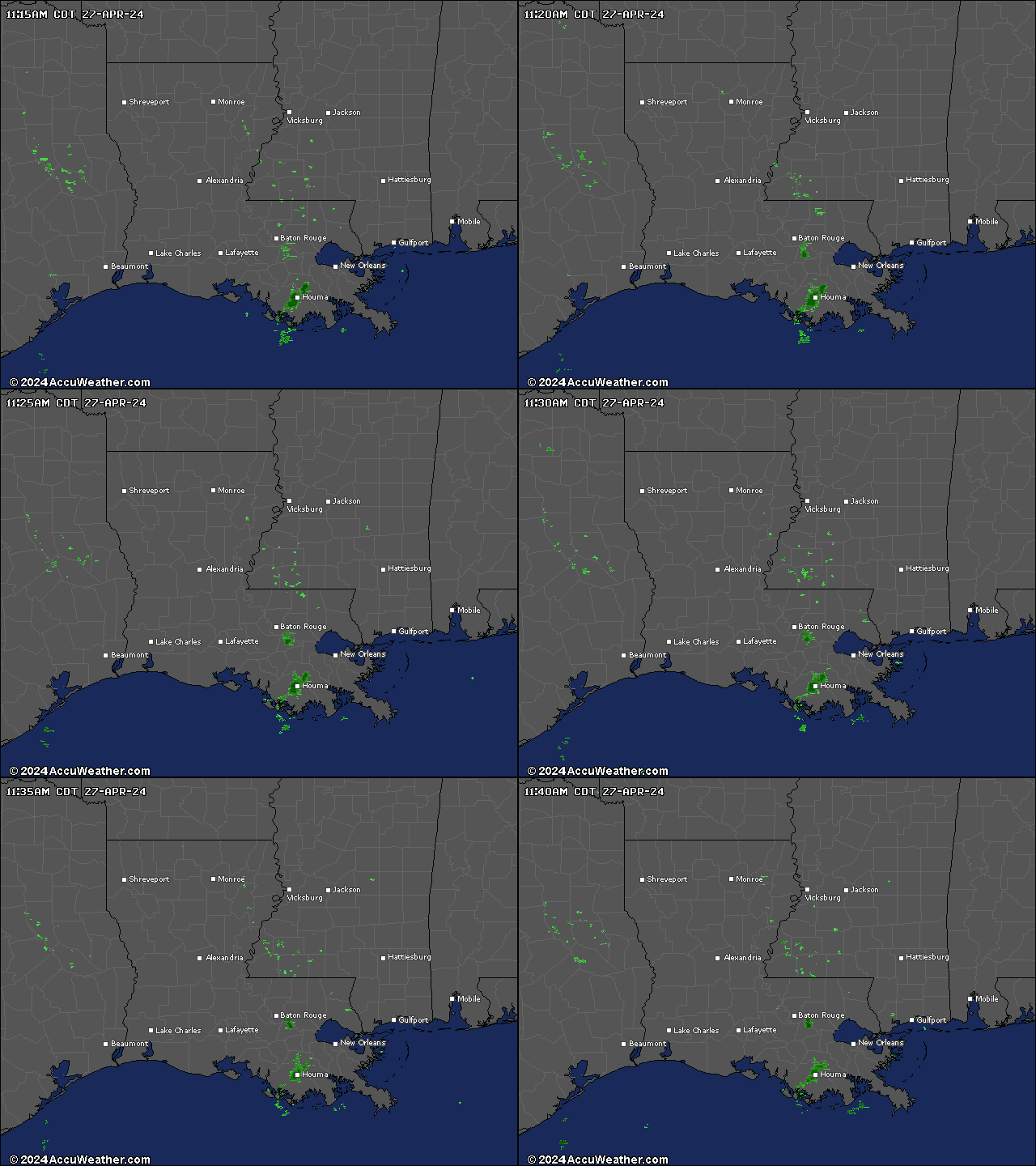
We have thunderstorms coming through here now. Time to shut down and take cover. The radar image I just looked at is really ugly.

inmasirla_.gif
 
Evening all!
Lots going on, been busy! Enjoying immaculate weather , 58 at night for a low, sunny and 76 during the day with low humidity:D Supposed to go into the weekend! Then it gets hot!:eek: Oh well, I'll be in the basement!!
The car will be cooler too this year, as I'm having the glass professionally tinted friday. Last summer was a killer, I should have head my head examined!! Black car with a glass roof !! Can you say oven??:eek: The tint should help that immensely!
Barry, keep the chin up, for attitude is worth a ton of cure. I learned that with my wife's cancer issue, and I believe that carried over to my coming back from a stroke as well. We'll keep you on the prayer list too!
One question for the computer geeks. One forum member's avatar doesn't show up when I am logged on from home on my new PC (Win 7 64 bit) but it does show up when I'm logged on with my old PC, or my phone. It's not the I'm hung up on "Old 97"s mug, just confused. Nobody else's avatar does this.
It's weird.:confused::confused::confused:
Maybe it's his Mod cloaking device interfering with your multispacial scans.
You may also have a plug in that is not installed. I am installing plugins as I type on a new machine.
 
Maybe it's his Mod cloaking device interfering with your multispacial scans.
You may also have a plug in that is not installed. I am installing plugins as I type on a new machine.

Hmmm, cloaking device? No doubt stolen from the Romulans;)
I must alert Starfleet!:rolleyes:
 
Good Morning All,
Hope all is well with everone.

Say Jeffrey,
I was trying to look up your general location in reference to the weather maps you posted to get a better idea of where Sunset/Sundown is located but the map just shows what appears to be that the location is North of the Mid point, approximately. of the states Southern Coast and inland about 250 miles?

It didn't say that your near any of the larger towns in Louisians so it was a bit hard to pinpoint. If I've got the town name correct Wiki-a-pedia said that location was the Sweet Potato capitol for a while.

Take care with the storms and don't get electra-fried, Ya-Hear?

Take care, man I'm up too late again.

Dang Me!
 
Say Jeffrey,
I was trying to look up your general location in reference to the weather maps you posted to get a better idea of where Sunset/Sundown is located but the map just shows what appears to be that the location is North of the Mid point, approximately. of the states Southern Coast and inland about 250 miles?

It didn't say that your near any of the larger towns in Louisians so it was a bit hard to pinpoint. If I've got the town name correct Wiki-a-pedia said that location was the Sweet Potato capitol for a while.
The town of Sunset has nothing to do with the tiny community of Sundown. They aren't even in the same part of the state. You won't find Sundown on any map. It doesn't have a store or post office, only a fire station. It's located in Vernon parish between Hawthorne and White Park, two more places that aren't on any map. The nearest towns are Leesville (31° 08' 37" N, 93° 16' 16" W) and Anacoco (31° 15' 10" N, 93° 20' 38" W).


Good morning. It's 69° and partly cloudy with a 20% chance of rain. The high will be 92° with a 30% chance of rain in the afternoon decreasing top 20% in the evening.

Storms came through yesterday ind screwed up the cable again. Except for brief periods here and there I couldn't get online and when I could the speed was so slow it'd take five minutes for a page to load. This happens a lot more often than I'd like and is more than mildly irritating. If it wasn't for my phone service I probably would have changed to satellite by now. Of course then I'd have the clouds to contend with. My Magic-jack needs an upload speed of at least 128 kb/s minimum to operate and satellite only provides 56 kb/s. Yeah, they talk about it being so fast on the TV ads but that's comparing to dial-up, sorta like comparing a two cylinder riding mower engine to a battery powered weed eater. Comparing the satellite speed to what I have right now is like comparing that same two cylinder mover engine to a small block V8. I've been looking at the new Magic-jack Plus that doesn't need to be connected to a computer like my existing Magic-jack does but it still needs to be connected to a modem, so the cable problem is still there. It'd be nice if it could work through the house wiring, then I could skip the cable altogether. But alas, it doesn't appear to work that way.

Today I need to see if I can get the layout cleaned up some. It gets cluttered so fast when I'm working on things.

P1011377-3.jpg
 
Good afternoon. It is mostly sunny and 75.
The runaway tree has been removed, and the plumbing issues have been resolved. Now if I could get my Zephyr troubles taken care of, I would be a happy guy.
 
I'm calling it a night a little early today. Managed to get alcohol in my eyes when I was changing out the dressing on my foot. The cap has one of those flip-top squirt things. I had flipped it up when I got the bottle out and when I picked it up it slipped a bit and I tightened my grip. Big mistake! A stream of alcohol shot of the squirt hole and hit me right between the eyes. That 90% alcohol makes your eyes burn bad. I flushed them real good but they've been aching all day. See y'all tomorrow.

P1011341-1.jpg
 
Good Afternoon all,
It's a fairly comfortable day in the foothills of central Calif.

Again I find myself sitting behind this computer too much rather than work on my layout.


Say Jeffrey,

You said:
The town of Sunset has nothing to do with the tiny community of Sundown. They aren't even in the same part of the state. You won't find Sundown on any map. It doesn't have a store or post office, only a fire station. It's located in Vernon parish between Hawthorne and White Park, two more places that aren't on any map. The nearest towns are Leesville (31° 08' 37" N, 93° 16' 16" W) and Anacoco (31° 15' 10" N, 93° 20' 38" W).


Thats appreciated as I wasn't quite sure where you were but the storms looked farther North than where I thought you were.

Ok Jeff, I did find Hawthorne Rd. which is West of Shreveport Hwy & North of Leesville with a couple of small lakes in the area. I assume[?] the little town of Hawthorne must be somewhere near?

Anyway, I now have a much better idea of where your at which isn't too far from the Texas border in relation to the storms.


It seems like a good time to take a nap to that's what I going to do.
Talk with you all later.
 
Sorry to hear of the slight mishap Jeff.

Some time back I had used some Blue Goo Menthol to rub on my leg/Knee and forgot to wash my hands good and got some in one of my eyes when I rubbed it due to an ich and man did it burn and tear, and for quite awhile too.

That taught me to wash real good after using that stuff. But it sure does releave a lot of pain!

Take care, hope your eyes are better.
 
Last edited by a moderator:
Good Afternoon all,
It's a fairly comfortable day in the foothills of central Calif.

Again I find myself sitting behind this computer too much rather than work on my layout.


Say Jeffrey,

You said:
The town of Sunset has nothing to do with the tiny community of Sundown. They aren't even in the same part of the state. You won't find Sundown on any map. It doesn't have a store or post office, only a fire station. It's located in Vernon parish between Hawthorne and White Park, two more places that aren't on any map. The nearest towns are Leesville (31° 08' 37" N, 93° 16' 16" W) and Anacoco (31° 15' 10" N, 93° 20' 38" W).


Thats appreciated as I wasn't quite sure where you were but the storms looked farther North than where I thought you were.

Ok Jeff, I did find Hawthorne Rd. which is West of Shreveport Hwy & North of Leesville with a couple of small lakes in the area. I assume[?] the little town of Hawthorne must be somewhere near?

Anyway, I now have a much better idea of where your at which isn't too far from the Texas border in relation to the storms.
There is no town of Hawthorne, just a small community scattered in the woods. It's a metropolis compared to Sundown which is very tiny. You heard of blink and you miss it? You don't have time to blink. There are two Hawthorne roads, east and west. West runs between hwy 171 (Shreveport hwy) and hwy 8 (Nolan Trace aka Texas hwy). The Sundown fire station is on Vernon Lake road and is a couple of miles from my home near Vernon Park road. Vernon Lake road is accessible from both hwy 8 and hwy 171. Not far north of Hawthorne on 171 is a small road called Ford Stewart road. That goes from 171 to Vernon Lake road. Ford Stewart is two miles long. As far as getting to Vernon Lake road on hwy 8, you found West Hawthorne road. Look where it comes out on hwy 8. A little farther west is Vernon Lake road. There are no signs for Sundown. Most people don't even know it exists as the survey markers (magnetic) were remove long ago. I know the old boundaries because my mother worked for an abstract company at one time. She knew where all the little community boundaries are, even the ones that existed only on paper, such as Sundown and Lyles. Lyles was commissioned and laid out in the 1920's as was Sundown. Neither town was built as something called World War II got in the way. Sundown was decommissioned in the 1950's and was forgotten. Lyles remained an unborn dream until the late 90's when the parish finally decommissioned it and released the land and Lyles, like Sundown ceased to exist. The boundary and survey markers for the streets are still there to be found by anyone wanting to search for them. Neither town had even a chance at life as neither ever got past the survey stage.
 
There is no town of Hawthorne, just a small community scattered in the woods. It's a metropolis compared to Sundown which is very tiny. You heard of blink and you miss it? You don't have time to blink. There are two Hawthorne roads, east and west. West runs between hwy 171 (Shreveport hwy) and hwy 8 (Nolan Trace aka Texas hwy). The Sundown fire station is on Vernon Lake road and is a couple of miles from my home near Vernon Park road. Vernon Lake road is accessible from both hwy 8 and hwy 171. Not far north of Hawthorne on 171 is a small road called Ford Stewart road. That goes from 171 to Vernon Lake road. Ford Stewart is two miles long. As far as getting to Vernon Lake road on hwy 8, you found West Hawthorne road. Look where it comes out on hwy 8. A little farther west is Vernon Lake road. There are no signs for Sundown. Most people don't even know it exists as the survey markers (magnetic) were remove long ago. I know the old boundaries because my mother worked for an abstract company at one time. She knew where all the little community boundaries are, even the ones that existed only on paper, such as Sundown and Lyles. Lyles was commissioned and laid out in the 1920's as was Sundown. Neither town was built as something called World War II got in the way. Sundown was decommissioned in the 1950's and was forgotten. Lyles remained an unborn dream until the late 90's when the parish finally decommissioned it and released the land and Lyles, like Sundown ceased to exist. The boundary and survey markers for the streets are still there to be found by anyone wanting to search for them. Neither town had even a chance at life as neither ever got past the survey stage.


With those directions I can almost pin point where your at, well almost, I did find Vernon Park Rd. where it turns Right off of Huckleberry Ln or Par Rd 168 and goes up and makes a Right hand curve that turns into Left hand curve and back into a Right hand curve and runs out till it turns into Par Rd 166 which makes a slight left hand curve at the end. This all follows the inlet from the lake Vernon I think it is. There is an unmarked Rd to the Right at about the point where Vernon Pk Rd and Par 166 meet.

Is that getting closer now?
Also why does VPR make the loop headed out as I described above, a rocky area or bit of a little hill or maybe a meadow area?

Take care,
 
Last edited by a moderator:
Good morning. It's clear and 58.
The tree that sought asylum in my yard has been removed, the drain pipes have been replaced, and the sewer stench has diminished to the point of being bearable.
I'm off to the hobby shop tomorrow with my Zephyr, to make sure it's not something I'm doing wrong, before putting it back in the mail Monday.
 
With those directions I can almost pin point where your at, well almost, I did find Vernon Park Rd. where it turns Right off of Huckleberry Ln or Par Rd 168 and goes up and makes a Right hand curve that turns into Left hand curve and back into a Right hand curve and runs out till it turns into Par Rd 166 which makes a slight left hand curve at the end. This all follows the inlet from the lake Vernon I think it is. There is an unmarked Rd to the Right at about the point where Vernon Pk Rd and Par 166 meet.

Is that getting closer now?
Also why does VPR make the loop headed out as I described above, a rocky area or bit of a little hill or maybe a meadow area?

Take care,
Vernon Park road and 166 are one and the same. The unmarked road going to the right is an old logging road that's been closed for many years. I'm on 167, also called Cable loop or Cabin Logs depending on what map you're looking at. Some of the older maps were based on the surveys for Sundown and show roads that never existed. Indeed, some of them are under water as the lake didn't exist when those old maps were made. One of the old maps that was printed back in the 40's shows a road that goes right through the middle of my parents yard. Back then that was part of a proposed housing district called Trammel Acres. It never came to fruition.
 
Good morning. It's 69°. The high will be 88°. It'll be mostly cloudy. There's a 40% chance of rain in the morning...then a 60% chance of rain likely in the afternoon. Locally heavy rainfall possible in the afternoon.

Looks like today will be just a bit on the damp side if not a bit soggy. I must get a bit of clean-up done on the layout. It's starting to disappear - again. Where there was scenery is a pile of tools and bits and pieces left from projects, bits of wire, a few vehicles. It looks like a hurricane and a tornado just gathered things up and dropped them in two piles along the front of the layout.

P1011316-1.jpg


A short video of this mornings train led by three GP9's and a U25C.
 
Cool bus, Jeffrey! Are they giving a show anywhere soon?;) I was a little fond of Laurie when I was much younger.:rolleyes:

Nice video of the trains. The excavators would normally be transported with the boom and bucket curled under with the bucket as close as possible to the frame and centered between the tracks. The models may not move that way and it really doesn't matter. Just throwing it out there for what it's worth.
 
Status
Not open for further replies.


Back
Top