The 60/40 Layout And Other Railway Related Things

ModelRailroadForums.com is a free Model Railroad Discussion Forum and photo gallery. We cover all scales and sizes of model railroads. Online since 2002, it's one of the oldest and largest model railroad forums on the web. Whether you're a master model railroader or just getting started, you'll find something of interest here.


Smudge: Elevator lighting is a 'depends' thing. Satellite ones are close to the fields and solely dependent on when the grower cuts and trucks product in. During that season, some are 24/7 and lit up; while others only run when they know something is due in. Terminals take in from all the Satellite's and operate 24/7 loading ships, trains and trucks. These have lighting all over the place for walkways, stairways, ladders and areas. As far as signage goes, that depends too. Major players want their names on the things and keep up with building maintenance pretty good. Smaller players not so much. If you think about it, it is your railroad and there is nothing to say that other companies can buy advertising space on that huge silo billboard. Gives 'I love lights' a real place now doesn't it? There is a Terminal close to DT Spokane where the paint was falling off the thing. 20 years ago they went out for bid on painting. $200,000 to 'get-r done'. I can just imagine what it would be today! So you have freedom of choice to be decrepit, bright and shiny or somewhere in-between. I am off to Spokane tomorra for my yearly eye exam and will try to get a few pix to post. Won't be at night, but you can see what there is around here.

Later
If you could that would be great, I'd like to get it reasonably accurate, I will weather the silo's at some point down the line, the're still a bit shiny, despite 3 layers of dull coat. And I have those floodlights I bought, so I can put them to use there I think, but on a separate switch
 
Not meaning to be discouraging here, but in the more recent eras, they don't have a lot of signs since they are the only place for miles around for grain farmers to go to, and they don't need the expense of advertising. But, trim back the white parts of the card and it will look much better. Many only have signs on the building itself, but not the silos, although they exist both ways, easier maintenance. As a side note, I know that you love lights, but most grain elevators are not lit at night, at least around here. They do have flashing red lights on top to warn aircraft though.
Here's one about 60 miles south of me.
View attachment 164253
Before I forget to ask, do you remember whether the lights were on some sort of pole or fixed to the top wall of the building ?


Smudge: Bad news ... sorta. Could not stop before my procedure - hit ice and snow which slowed us down. Also forgot about the 'load limits' for breakup between the MT state line and SR95/US2 at Bonners Ferrry. That slows down ALL trucks to 30Mph; normally 60Mph. Idaho's roads are not built to the latest and greatest standards in this location. Breakup happens when everything starts to thaw. Water goes away leaving an 'air pocket' under the pavement. Weight ( and speed apparently ) can 'break' the pavement. Got to my appointment 2 minutes before drop dead time. Afterward, I tried to get to a couple of places for pix with no luck: turn lanes blocked, thick mud on the side roads I did not want to play with in the Edge.

Anyway; maybe these will help. The links are for the locations using google earth. Click'm and you will see what you can see. I do not know how big the resulting image will be from the link, you may have to search ( in pix ) for a grain elevator looking thing. Note: In case you do not know: see that little people figure at the bottom right corner of the screen? Click it and 'Blue' lines should appear down the middle of the street(s). Click anywhere on the blue line to bring up ground level pix. You then need to swing 'the camera' around for the building you want. Might take you a couple of tries to get the 'right' placement to swing the camera.

1st is the ADM mill mix plant.

Next is another ADM.

Last is the Purina ( think dog food ) plant.

Hope this helps a little!

Later
 
Smudge: Bad news ... sorta. Could not stop before my procedure - hit ice and snow which slowed us down. Also forgot about the 'load limits' for breakup between the MT state line and SR95/US2 at Bonners Ferrry. That slows down ALL trucks to 30Mph; normally 60Mph. Idaho's roads are not built to the latest and greatest standards in this location. Breakup happens when everything starts to thaw. Water goes away leaving an 'air pocket' under the pavement. Weight ( and speed apparently ) can 'break' the pavement. Got to my appointment 2 minutes before drop dead time. Afterward, I tried to get to a couple of places for pix with no luck: turn lanes blocked, thick mud on the side roads I did not want to play with in the Edge.

Anyway; maybe these will help. The links are for the locations using google earth. Click'm and you will see what you can see. I do not know how big the resulting image will be from the link, you may have to search ( in pix ) for a grain elevator looking thing. Note: In case you do not know: see that little people figure at the bottom right corner of the screen? Click it and 'Blue' lines should appear down the middle of the street(s). Click anywhere on the blue line to bring up ground level pix. You then need to swing 'the camera' around for the building you want. Might take you a couple of tries to get the 'right' placement to swing the camera.

1st is the ADM mill mix plant.

Next is another ADM.

Last is the Purina ( think dog food ) plant.

Hope this helps a little!

Later
Wow, yeah, think it would have been a bad idea to stop in those conditions anyway, glad you made it to your appointment, just.
It's not a problem, thanks for the links, I'll take a look when I get home, thanks for trying anyway.
 
Wow, yeah, think it would have been a bad idea to stop in those conditions anyway, glad you made it to your appointment, just.
It's not a problem, thanks for the links, I'll take a look when I get home, thanks for trying anyway.
No problem! Want pix anywho so I will be back.
Also, there are a couple more that I wanted to include but forgot.

Kalama, WA - no ground level pix though;

And TemCo a little south of the above.

Finally the granddaddy of them all ( near me ), for those that need to do something with those 270 degree loops!
This is NW Portland, OR

A little to the North and slightly East from the last one shows Columbia Grain - little smaller, still could be incorporated in return loop
 
Last edited:
No problem! Want pix anywho so I will be back.
Also, there are a couple more that I wanted to include but forgot.

Kalama, WA - no ground level pix though;

And TemCo a little south of the above.

Finally the granddaddy of them all ( near me ), for those that need to do something with those 270 degree loops!
This is NW Portland, OR

A little to the North and slightly East from the last one shows Columbia Grain - little smaller, still could be incorporated in return loop
Thanks, all good views I can use. :)
 
Smudge: Bad news ... sorta. Could not stop before my procedure - hit ice and snow which slowed us down. Also forgot about the 'load limits' for breakup between the MT state line and SR95/US2 at Bonners Ferrry. That slows down ALL trucks to 30Mph; normally 60Mph. Idaho's roads are not built to the latest and greatest standards in this location. Breakup happens when everything starts to thaw. Water goes away leaving an 'air pocket' under the pavement. Weight ( and speed apparently ) can 'break' the pavement. Got to my appointment 2 minutes before drop dead time. Afterward, I tried to get to a couple of places for pix with no luck: turn lanes blocked, thick mud on the side roads I did not want to play with in the Edge.

Anyway; maybe these will help. The links are for the locations using google earth. Click'm and you will see what you can see. I do not know how big the resulting image will be from the link, you may have to search ( in pix ) for a grain elevator looking thing. Note: In case you do not know: see that little people figure at the bottom right corner of the screen? Click it and 'Blue' lines should appear down the middle of the street(s). Click anywhere on the blue line to bring up ground level pix. You then need to swing 'the camera' around for the building you want. Might take you a couple of tries to get the 'right' placement to swing the camera.

1st is the ADM mill mix plant.

Next is another ADM.

Last is the Purina ( think dog food ) plant.

Hope this helps a little!

Later
The one of ADM milling is fantastic, love to be able to copy the weathering on the silo, I'll have to find something to practice on to try and replicate that, also need to find something to replicate the walkway on top of the silo, I see that has windows and doors, that would look great too, big thank you for taking the time to find these for me.
 
meant to post this at the weekend and forgot

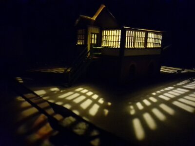
LNER Signal Box, finally got the stairs done, roof's not fitted as I still have to make and fit the interior.

1679000319423.jpeg


Still have to add a resistor to this, as it's a little too bright.
 

Attachments

  • 1679000402060.jpeg
    1679000402060.jpeg
    218.3 KB · Views: 204


Affiliate Disclosure: We may receive a commision from some of the links and ads shown on this website (Learn More Here)

Back
Top